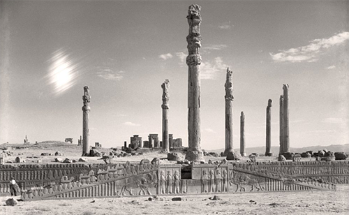
Exhibit Features Archival Images of Persepolis

The following appeared in UChicago News on 9 October 2015.
A new exhibition at the Oriental Institute will give visitors a rare glimpse inside the ancient city of Persepolis. “Persepolis: Images of an Empire,” which opens Oct. 13, includes archival photographs and a new multimedia presentation that document an astounding imperial complex of palaces constructed by the Persian kings Darius, Xerxes and Artaxerxes I and III, who ruled between 522 and 338 B.C. in present-day southwest Iran.
These Persian kings were the greatest powers in the ancient world, ruling the entire Middle East and battling for supremacy against their rivals, the Greeks. This half-century conflict, culminating in battles with Alexander the Great, has been the subject of popular interest in films such as “300.”
The tremendous political and economic power of the Persian kings was expressed by the scale of the architecture at Persepolis, especially the monumental audience halls where grand stairways were decorated with finely carved images of people from throughout the kingdom carrying precious gifts to their Persian overlords.
Persepolis was excavated from 1931 through 1939 by Oriental Institute archaeologists Ernst Herzfeld and Erich Schmidt. The team documented the site in dramatic black-and-white views of the architecture and the rugged surrounding terrain. The photographs capture the forest of columns that tower over the site’s raised terrace, which supported grand ceremonial audience halls, palaces, great stone portals and carved scenes of the kings and their courtiers.
“[These photographs] are hauntingly beautiful windows to the past,” said exhibit curator Kiersten Neumann. “They present a promise of the opulence and lavishness that was Persepolis, yet they also capture its solitude and melancholy—the resolute ruins of a once equally determined empire.”
Approximately 3,700 photographs were taken during the Oriental Institute’s expedition. From 1937 to 1939, the expedition used a Waco cabin biplane, christened “Friend of Iran,” to document the site and the surrounding region. This was an important technological advance: from the air, the archaeologists could see the outlines of buildings that were then buried under the sand. As excavator Schmidt wrote, “In 13 hours flying over the environs of Persepolis, we succeeded in mapping more than 400 ancient sites…a task of years if carried out on the ground.”
The multimedia presentation continues that tradition of innovation, juxtaposing vintage aerial photographs with new satellite imagery to show how much the terrain has changed over the last 80 years, and using these images to create a 3-D model of the original architecture.
“The exhibit and new 3-D mapping continues to demonstrate the vital importance of the Oriental Institute’s original photographic and documentary archives from over 80 years ago,” explained Jack Green, the museum’s chief curator.
The exhibit also features quotes from travelers, including Lord Byron and William Francklin, an officer of the British East India Company who visited the site in the early 1800s, expressing their wonder and admiration of the ruins. A final panel explores the question “What Was Persepolis?” with comments from modern scholars who try to solve the mystery of the role and purpose of the grand complex.
The exhibit will be on view through Sept. 11, 2016.